|
Causes |
|||
| causes |
|
Zoom is broken in geomap initial view | Closed |

[ZBXNEXT-6945] Geographical map widget Created: 2021 Sep 24 Updated: 2024 Apr 10 Resolved: 2021 Dec 13 |
|
| Status: | Closed |
| Project: | ZABBIX FEATURE REQUESTS |
| Component/s: | Frontend (F) |
| Affects Version/s: | None |
| Fix Version/s: | 6.0.0alpha6, 6.0 (plan) |
| Type: | New Feature Request | Priority: | Minor |
| Reporter: | Rostislav Palivoda (Inactive) | Assignee: | Miks Kronkalns |
| Resolution: | Fixed | Votes: | 7 |
| Labels: | None | ||
| Remaining Estimate: | Not Specified | ||
| Time Spent: | Not Specified | ||
| Original Estimate: | Not Specified | ||
| Attachments: |
|
||||||||
| Issue Links: |
|
||||||||
| Team: | |
||||||||
| Sprint: | Sprint 80 (Sep 2021), Sprint 81 (Oct 2021), Sprint 82 (Nov 2021), Sprint 83 (Dec 2021) | ||||||||
| Story Points: | 6 | ||||||||
| Description |
|
Currently, there is no way to display hosts on geographical maps in a convenient fashion. Zabbix must provide a widget to close this gap.
|
| Comments |
| Comment by Brian van Baekel [ 2021 Sep 24 ] |
|
I love this feature, and glad to see the approach. I am missing 1 thing that I came across building the own implementation: option to choose marker types, perhaps based on tags or inventory field(icon mapping in maps idea)? Would it be possible to add that in the feature as well? |
| Comment by Miks Kronkalns [ 2021 Oct 04 ] |
|
Hi brian.baekel, that might be useful but currently we are going to implement only basic functionality. Adding icon mapping to geographical map would ask more effort then we can afford to invest now. Icon mapping is not reusable in this context without negative side effects. |
| Comment by Alexei Vladishev [ 2021 Oct 18 ] |
|
Just a quick update. We hope to deliver Geo maps in alpha6 of Zabbix 6.0 in a few weeks time. Dev work is nearly finished, waiting for QA. |
| Comment by Miks Kronkalns [ 2021 Oct 19 ] |
|
Available in development branch feature/ZBXNEXT-6945-5.5. |
| Comment by Brian van Baekel [ 2021 Nov 05 ] |
|
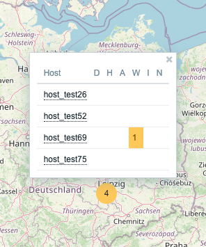
Hi all, We're playing around with this feature - and wow, nice job! It looks great! During playing around, i found 1 thing that was causing a 'mmmmmmm' moment, attached the screenshot.
Not sure what the best solution is, or even if there is a solution needed, but it might be interesting to think about this 'problem' |
| Comment by Alexei Vladishev [ 2021 Nov 05 ] |
|
brian.baekel, I find it confusing too. Miks.Kronkalns, do we really suppose to display a sum of Problems and OK? Shall we display number of problems only? EDIT: We display number of hosts having problems in the cluster view and then number of problems for each individual host. Ignore my question, sorry. It is confusing indeed. Let's leave it as it is for now, if we have time we could introduce additional options later on, perhaps even before 6.0. |
| Comment by Nathan Liefting [ 2021 Nov 05 ] |
|
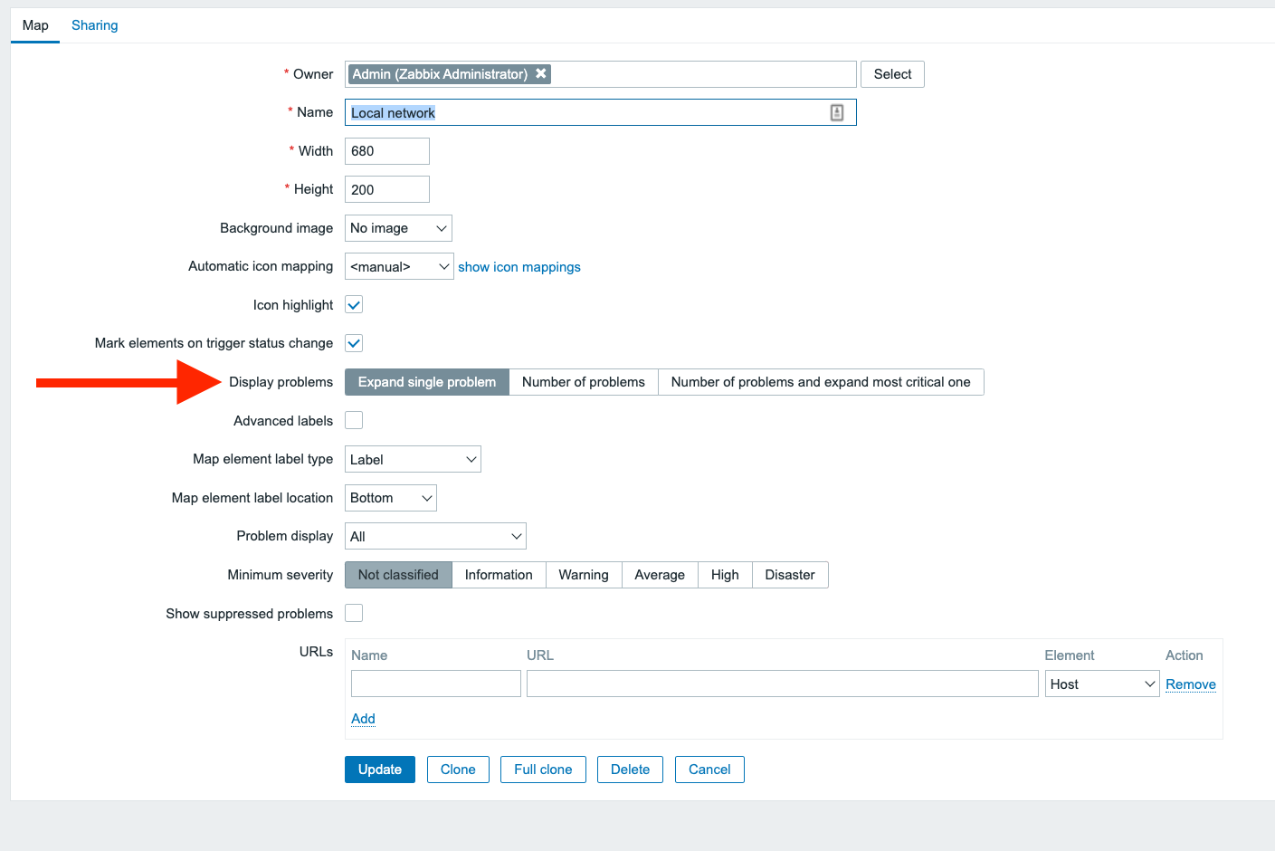
Hi Alexei, It might be a good idea, if you do decide to implement it where only hosts with problems will display to give the user the option to decide what view is best for them. Something like adding a "Show hosts problems", "Show all hosts", "Show hosts and problems seperatly" slider in the Widget options would make sure 'everyone' can pick their flavour with this feature.
Basically a choice option like we already have in Zabbix maps:
|
| Comment by Miks Kronkalns [ 2021 Nov 05 ] |
Digit on the cluster circle shows number of hosts joint into cluster (all hosts not hosts having problems only). To show only hosts having problems, severity filter must be used. |
| Comment by Adail Horst [ 2021 Nov 05 ] |
|
+1 #EveryZ ! Congrats Alexei. |
| Comment by Adail Horst [ 2021 Nov 05 ] |
|
Please don't forget to add the "routes" feature and real time events on map and custom menus. Only to me understand... You guys implement geolocation in host group level ? Not on host level ? Many samples of this way of implementation and possibilities are available on google image search.
|
| Comment by Marcio [ 2021 Nov 05 ] |
|
Muito Bom !! Parabéns !! #everyz |
| Comment by Miks Kronkalns [ 2021 Nov 05 ] |
|
spaww, not really... each map marker is a host not a host group. And closest markers may be grouped into clusters but that's not based on host groups. |
| Comment by Adail Horst [ 2021 Nov 05 ] |
|
Miks.Kronkalns , ok so the LAT/LON are defined on host level right, using the data on inventory ? I ask this because many users here in Brazil use this on Everyz (and still using old versions of Zabbix because I dont migrate EveryZ to latest version of Zabbix... #sorry). So the "grouped cluster view" is not defined by zoom level ? for example... when you see the "country view" you have some balls with the grouped view of hosts ... and after that you make a "drill down" and see with more details at host level or some liked ? Its not much clear for me now #sorry. |
| Comment by Adail Horst [ 2021 Nov 05 ] |
|
This implementation use Leaflet ? Will support plugins ? |
| Comment by Adail Horst [ 2021 Nov 05 ] |
|
I ask about plugins because some very good features for ISPs are related with AREA design... for example... if HOST-A is down... this area (a polygon) don't have internet connection... so... put HOST-A in alert status and paint this area with a RED TRANSLUCENCY color... to NOC team understand the implication of HOST-A is down (how much users are affected). |
| Comment by Alexei Vladishev [ 2021 Nov 05 ] |
|
spaww, this functionality is quite well described in the attached ACC document. Please read it. It will be released in 6.0 alpha very soon, so perhaps you may try it as well. |
| Comment by Miks Kronkalns [ 2021 Nov 05 ] |
|
Implemented in:
|
| Comment by Adail Horst [ 2021 Nov 05 ] |
|
Cool @Alexei Vladishev I will read the PDF now. I see this document in attachments but for some reason doesn't appear as a "PDF Icon" ... so I don't click on it! |
| Comment by Adail Horst [ 2021 Nov 05 ] |
|
@Alexei I don't know if is possible add this at this moment... but... try to add support to icon mapping on this map... (I cant locate on documentation info about this - ACC_ Geographical map widget - v1.0.pdf) . With this the map will be much more rich and the computational costs and interface costs for define this is not expressive. Exists too a Leaflet plugin to open the clusters as an spiral this can be a good Idea (in latest version of EveryZ we use it and the result are really very nice). Maybe in some cases (like a very small geomap) this can be a option because the number of opened hosts can be greater than the area. So by the documentation at this moment we don't will have polygons / lines / areas right?
|
| Comment by Brian van Baekel [ 2021 Nov 05 ] |
|
@Adail: If you read back, it was mentioned already that icon mapping is not on the list of 'implement before release', as there is only so much you can do in a given time period with the given resources available. I think the specs and comments are clear about the lines/polygons So far i am extremely happy with how this is implemented(look/feel) and just hope that in the future resources are available to enhance it. |
| Comment by Adail Horst [ 2021 Nov 05 ] |
|
Yes Brian, we all are Happy! I remember in 2016 I talk with Alexei about this feature and how has this is important for all Zabbix Users. |
| Comment by Magno Monte Cerqueira [ 2021 Nov 05 ] |
|
Go, Go #EveryZ |
| Comment by Raphael Rodrigues [ 2021 Nov 05 ] |
|
Great to have this feature native in zabbix. |
| Comment by Dimitri Bellini [ 2021 Nov 11 ] |
|
Hi DevTeam, |
| Comment by Alexei Vladishev [ 2021 Nov 11 ] |
|
dimitri.bellini, right mouse click on the map to save your current view as default and reset to the original view. |
| Comment by Valdis Murzins [ 2021 Nov 11 ] |
|
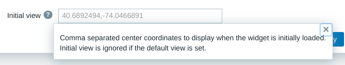
dimitri.bellini, for current user it is, as Alexei explained. If the position should be changed for all users, then in widget configuration you have to update "Initial view" field in format: <latitude>,<longitude>,<zoom>. |
| Comment by Dimitri Bellini [ 2021 Nov 11 ] |
|
@Alexei good to know ... I miss it !! Thanks so much |
| Comment by Miks Kronkalns [ 2021 Dec 02 ] |
|
Updated user manual:
Updated API documentation: |